
Out of Climbing Power
Induction icing overwhelms a Beech aircraft on a cross-country flight.
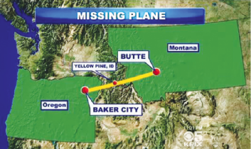
On December 1, 2013, about 1303 Mountain Standard Time, a Beech B36TC, N36ML, was destroyed when it impacted terrain while maneuvering near Yellow Pine, Idaho. The airplane was registered to and operated by the pilot under the provisions of Title 14 Code of Federal Regulations Part 91. The instrument rated private pilot and his four passengers were fatally injured. Instrument meteorological conditions prevailed and an instrument flight rules (IFR) flight plan was filed for the personal flight. The 234 nautical mile cross-country flight originated from Baker City Municipal Airport (BKE) Baker City, Oregon, about 1222 with an intended destination of Butte, Montana.
Information provided from the Federal Aviation Administration revealed that the flight departed from BKE under visual flight rules. At 1226, when the aircraft was about 10 miles south of BKE at an altitude of about 6,200 feet, the pilot contacted the FAA Air Route Traffic Control Center (ARTCC) requesting to activate an IFR flight plan to Butte, Montana.
At 1230, the controller issued the accident airplane the BKE altimeter and identified the airplane was located about 13 miles south of the BKE VOR. The controller then cleared the flight to Butte as filed and directed the pilot to climb and maintain 13,000 feet. The pilot acknowledged the clearance and altitude. The controller followed with a clearance for the flight to proceed direct to the Donnelly VOR. At 1240, the controller advised the pilot that the McCall Municipal Airport (MYL), McCall, Idaho, altimeter setting was 30.04. The pilot acknowledged about one minute and six seconds later. At 1256, the controller asked the pilot to confirm he was level at 13,000 and established on victor airway 121. The pilot responded with, “Negative, three six mike lima’s picking up too much ice, uh, we’d like to divert to, uh, Salmon.”
Shortly after, the pilot requested to descend to 11,000 feet. The controller advised the pilot to maintain 12,000 feet for terrain clearance. The pilot acknowledged 12,000 feet.
At 1257, the controller then asked the pilot if he would like to divert and the pilot subsequently verified that he would like to divert to Salmon. The controller cleared the pilot to Salmon via direct to the Salmon VOR and again instructed the pilot to maintain 12,000 for terrain clearance. The pilot acknowledged with “Maintain one two thousand six mike lima.”
At 1300, the controller asked the pilot to confirm he was still on victor airway 121 and the pilot responded with “Establishing victor 121.” The controller directed the pilot to turn right 15 degrees to be established on the airway. The pilot acknowledged. The controller then issued the pilot a low altitude alert, instructing him to check his altitude immediately. The controller stated that the minimum IFR altitude was 11,900 and instructed the pilot to climb and maintain 12,000 feet immediately. When asked to say altitude, the pilot advised that he was at 11,500 and climbing. The controller reiterated to the pilot that they had to maintain 12,000 feet for terrain.
At 1301:04, the pilot advised the controller that he was having engine problems and 15 seconds later advised that he needed to “go to three uniform two immediately.” The controller asked the pilot to verify his altitude, which the pilot responded he was at 10,000 feet. The controller then asked the pilot if he was able to climb, and the pilot responded “negative.” The controller advised the pilot that MYL was 24 miles behind him and asked if he wanted to divert. The pilot responded affirmatively and asked for guidance. The controller suggested a heading of 253 degrees and reminded the pilot that the minimum IFR altitude was 11,900.
At 1302, the pilot reported, “36ML just lost its engine” and asked the controller to “Say again heading for six mike lima.” The controller advised that MYL was at the pilot’s six o’clock position and suggested a heading of 253 degrees, adding that 3U2 was right below their position. The controller stated that he had information for the airport and asked the pilot if he’d like that information. There was an unintelligible response that could not be associated with any specific aircraft. The controller attempted to relay communications via other aircraft in the area and broadcast 3U2 airport information to N36ML in the blind. There were no further communications with N36ML.
The FAA subsequently issued an Alert Notification (ALNOT) at 1328. The United States Air Force Rescue Coordination Center (ARCC), Civil Air Patrol, local law enforcement, Idaho Air National Guard, Idaho Department of Aeronautics, and volunteers commenced search and rescue operations throughout the area where radar contact was lost. There were no reported ELT signals within the area of the last radar target.
The wreckage was located in snow covered wooded mountainous terrain on January 10, 2014 by a ground search team about 1.5 miles east of the last recorded radar target.
Personnel Information
The pilot, age 51, held a private pilot certificate with an airplane single-engine land and instrument airplane ratings. A second-class airman medical certificate was issued to the pilot on March 27, 2013, with the limitation stated “must wear corrective lenses.” The pilot reported that he had accumulated a total of 1,050 total flight hours at the time of his most recent medical application. The pilot’s logbook was not located.
Aircraft Information
The six-seat, low-wing, retractable-gear airplane, serial number (S/N) EA-375, was manufactured in 1983. A Continental Motors TSIO-520-UB3F rated at 300 horsepower powered it. The airplane was also equipped with a McCauley 3A32C406-C adjustable pitch propeller. Review of partial copies of the aircraft logbooks revealed that the most recent annual inspection was completed on June 3, 2013, at a tach time of 1,611.85 hours. The engine was overhauled on March 19, 2010, and subsequently installed on the airframe on April 1, 2010, at a tach time of 1,275.67 hours.
Review of the Raytheon Aircraft Company model B36TC pilot operating handbook, section 2, heading KINDS OF OPERATIONS states in part “…flight in icing conditions prohibited.”
Section 3, Emergency Procedures, revealed that under the heading “BLOCKED INDUCTION SYSTEM,” a checklist included the following:
1. Alternate Air T-Handle … PULL AND RELEASE
2. See INDUCTION SYSTEM BLOCKAGE later in this section.
The heading titled “INDUCTION SYSTEM BLOCKAGE,” stated in part “… if the alternate induction air door becomes stuck in the closed position, it can be opened by: ALT AIR PULL & RELEASE T-Handle (lower left sub panel) … PULL AND RELEASE. The section further states, “With the induction air filter completely blocked, the alternate air opening will provide sufficient air to allow the engine to develop maximum continuous power up to approximately 13,000 feet. Above that altitude, the manifold pressure will drop at a rate of approximately 1 inch per 1,000 feet.”
Section 7, Systems Description, heading INDUCTION SYSTEM ICING states in part, “… the possibility of induction system icing is reduced by the non-icing characteristics of the Bonanza’s fuel injected engine and an automatic alternate induction air source. Under certain conditions, however, impact ice can form at several points in the induction system.
If the air intake or filter becomes clogged with ice, a spring-loaded door in the air intake duct will open automatically and the induction system will operate on alternate air. If the alternate air source door becomes frozen in the closed position, a pull-and-release T-handle is provided to force the door open. With a completely blocked induction filter, full power can be expected up to approximately 13,000 feet.”
The airplane was last refueled at Baker Airport’s self-serve pump on November 27, 2013. The amount of fuel was undetermined due to a system recording error.
Meteorological Information
A National Transportation Safety Board (NTSB) staff meteorologist prepared a factual report for the area and timeframe surrounding the accident. The National Weather Service (NWS) regional radar mosaic for 1300 depicted a large area of echoes to the north of the accident site and no significant echoes over the accident site or over the McCall area, which was reporting light rain at the time of the image.
The NWS Weather Depiction Chart for 1200 depicted an area of IFR conditions by a shaded contour over the Washington and Oregon coasts, and a separate area of eastern Washington and northern Idaho, surrounded by an area of marginal visual flight rules (MVFR) conditions.
A second area of MVFR conditions was depicted extending over eastern Oregon, southern Idaho, and into western Wyoming, which included the accident site. Two small areas of IFR conditions were embedded within the region.
The closest weather reporting facility to the accident site was from McCall Municipal Airport (MYL), McCall, Idaho, located approximately 27 miles west at an elevation of 5,024 feet and along the immediate route of flight. At 1251, recorded weather conditions were wind from 140 degrees at 11 knots, visibility nine miles in light rain, ceiling overcast at 2,400 feet above ground level (agl), temperature 2C, dew point 0C, altimeter 30.04 inches of mercury (Hg), remarks: automated observation system, sea level pressure 1017.9-hPa, hourly precipitation 0.03 inches, temperature 2.2C, dew point 0C.
The closest upper air sounding or rawinsonde observation (RAOB) was from the NWS Boise (BOI), Idaho, located approximately 90 miles south of the accident site at an elevation of 2,867 feet. The 1700 sounding depicted a surface based temperature inversion to 1,500 feet agl with the lifted condensation level (LCL) immediately above at 1,914 feet agl (4,781 feet msl), and a convective condensation level (CCL) 7 at 4,988 feet agl (7,855 feet msl). The expected top of the clouds was at 13,465 feet. The freezing level was identified at 8,455 feet with the sounding indicating a relative humidity greater than 80 percent from 8,000 to 12,000 feet with temperatures below freezing that supported icing conditions.
At the accident airplane cruising level of 13,000 feet the wind was from 300 degrees at 53 knots with a temperature of -8.5C, with a potential for trace of rime type icing. The icing potential increased at lower levels and reached a 77 per cent probability of moderate clear type icing at 8,500 feet. Between 12,000 and 11,000 feet there was an approximately 80 per cent probability of light clear icing with relative humidity of 95 per cent and temperatures between -7 and -5 C.
The Geostationary Operational Environmental Satellite number 15 (GOES-15) satellite image for 1300 depicted several bands of low, mid, and high clouds over the area. The radiative cloud top temperature over the last radar target was -59.16C, which corresponded to cloud tops near 35,000 feet and indicated cirrostratus clouds. Several lenticular cloud bands were also observed supporting mountain wave activity over Oregon, southern Idaho, and northern Nevada, with overcast clouds over the accident site.
There were six pilot reports of light to moderate rime icing conditions below 18,000 feet scattered over Idaho prior to the accident, and nine reports after the time of the accident. There were also several reports of mountain wave activity and of light to moderate turbulence at altitudes above 18,000 feet. After the time of the accident there were also two urgent pilot reports from aircraft reporting moderate to severe turbulence in the vicinity of Idaho Falls over southern Idaho.
A full series of Airmen’s Meteorological Information (AIRMETs) issued by the NWS were current for the timeframe and intended route of flight. The active AIRMETS included AIRMET Zulu for moderate icing, AIRMET Sierra for mountain obscuration and AIRMET Tango for low-level windshear and turbulence.
The pilot of N36ML logged on to the Direct Users Access Terminal System (DUATS) and filed an instrument flight plan at 1200 on December 1 with a requested altitude of 13,000 feet. No formal weather briefing information was requested on the DUATS system and there were no records of any contact with the FAA contract Flight Service Station. It is unknown if the pilot utilized any additional sources of weather prior to the flight.
Wreckage and Impact Information
Examination of the accident site by representatives of Textron Aviation under the supervision of the NTSB IIC revealed the airplane impacted terrain about 1.6 miles northwest of the Johnson Creek Airport (3U2) at an altitude of about 7,619 feet msl. The initial point of contact was identified by a group of about five topped trees, about 40 feet in height. A swath of seven topped trees, each reduced in height as the debris path progressed on a heading of about 078 degrees magnetic. Portions of right and left wing, and tail cone were observed within the swatch of topped trees.
The aft portion of the fuselage, vertical stabilizer, rudder, and elevators were located about 104 feet from the initial point of contact. A large impact crater was observed immediately adjacent to the aft fuselage. Portions of left and right wing structure were observed between the aft fuselage and the forward portion of the fuselage and engine, which was located about 138 feet from the initial point of contact. All major structural components of the airplane were located within the wreckage debris path.
The engine and remaining attached forward airframe structure was found inverted and exhibited fire damage. A portion of the right inboard wing was found folded upward and positioned over the forward fuselage structure. The aft portion of the fuselage exhibited fire damage. The cockpit area was fire and impact damaged. Continuity was established from the cockpit engine controls forward to the engine.
Examination of the recovered wreckage by representatives from Textron Aviation and Continental Motors revealed that the fuselage was fragmented into multiple sections and exhibited fire damage. The engine remained attached to the airframe via various wires and hoses. The induction system from the induction air filter aft was intact and fire damaged.
The alternate induction air door remained attached and exhibited thermal damage. The spring was intact and remained attached to its respective mounts. The control cable was thermally damaged and remained attached to the actuator arm, however, it was separated about an inch from the attach point. The remaining portion of the cable was continuous to the cockpit area. The actuator arm functioned by hand and the alternate induction air door opened and closed freely.
The instrument panel was thermally damaged with multiple instruments displaced. Partial flight control continuity was established throughout the airframe to all primary flight controls. Multiple separations in the flight control system were observed. All separations exhibited signatures consistent with tension overload.
The right wing was displaced from the fuselage and separated into multiple sections. The leading edge structure of the inboard portion of the right wing from the flap aileron junction to the wing root was displaced to the main wing spar. The left wing was displaced from the fuselage, separated into multiple sections, and exhibited slight thermal damage. The leading edge structure of the left wing from the flap aileron junction was separated from the main spar inboard to the wing root. A circular impression was observed on the outboard portion of the separated leading edge structure.
The vertical stabilizer was separated from the airframe. The leading edge of the vertical stabilizer exhibited a circular impression on the left side from the base of the stabilizer to about mid height. The right side of the vertical stabilizer exhibited buckling from the impression aft to the aft spar. The rudder was separated from all its mounts. The rudder was bent and buckled throughout and exhibited fire and thermal damage.
The left horizontal stabilizer was separated from the fuselage. The inboard portion of the left stabilizer was bent and buckled from the leading edge to the trailing edge. The left stabilizer aft spar was mostly separated from the stabilizer. The right horizontal stabilizer was separated from the fuselage. The leading edge of the right horizontal stabilizer from the root to about mid span was torn away from the spar and bent downward. A portion of the right horizontal stabilizer leading edge skin was compressed aft to the spar and exhibited a circular impression. The leading edge structure exhibited a downward circular impression at about mid span.
Examination of the recovered engine revealed that the starter and the right magneto were separated from their respective mounts. All six cylinders remained attached. The exhaust remained intact and exhibited impact damage. The induction system for cylinders two, four, and six, were impact damaged and one, three, and five were intact. The induction crossover balance tube was crushed upward. The top sparkplugs, fuel pump, vacuum pump, and starter adapter were removed. All six cylinders were examined internally using a lighted borescope and were unremarkable. The engine was rotated by hand using a hand tool attached to the crankshaft propeller flange. Rotational continuity was established throughout the engine and valve train. Thumb compression and suction was obtained on all six cylinders.
The top sparkplugs were removed and examined. The number one and six sparkplugs were damaged. All six sparkplugs were oil coated and exhibited normal wear signatures.
The turbocharger was intact and remained attached to the engine and exhibited thermal damage. The turbocharger would not rotate by hand, however, debris was observed within the turbine side. The waste gate was intact and thermally damaged. The turbo controller was intact and thermally damaged. The relief valve was intact and thermally damaged.
The propeller was separated from the crankshaft propeller flange. Propeller blade No. One was separated from the propeller hub and exhibited slight twisting near the blade tip and chord-wise striations at about mid-span. Propeller blade No. Two was intact and exhibited slight aft bending. Propeller blade No. Three was bent aft about 12 inches from the blade tip and exhibited slight leading edge gouging at the tip. No evidence of any preexisting mechanical malfunctions was observed with the recovered airframe and engine that would have precluded normal operation.
Medical and Pathological Information
The Valley County Coroner conducted an autopsy on the pilot on January 17, 2014. The medical examiner determined that the cause of death was “… severe blunt force trauma.”
The FAA’s Civil Aeromedical Institute (CAMI) in Oklahoma City, Oklahoma, performed toxicology tests on the pilot. According to CAMI’s report, volatiles, and drugs were tested, and had positive results for 46 (mg/dL, mg/hg) ethanol detected in muscle and no ethanol was detected in liver.
Tests and Research
A Garmin GPSMap 396 was recovered from the wreckage and subsequently shipped to the NTSB Vehicle Recorders Laboratory, Washington, DC for further examination. Power was applied to the GPS unit and the data was successfully downloaded. The GPS unit contained 40 recorded sessions from July 13, 2013 to December 1, 2013.
Two flights were recorded on November 27, 2013, one from BKE to Butte, Montana, and one returning to BKE. The tracks to and from Butte were predominantly a direct course over mountainous terrain. Review of the track log from the day of the accident depicted a departure from runway eight at BKE. The flight continued on a southerly course until turning to an easterly course at 1231. The data depicted that the flight leveled off at an altitude of about 13,000 feet, at 1237. The flight continued on an easterly heading with altitudes fluctuating around 13,000 feet and groundspeeds between 200 and 228 knots. At 1244, a decrease in groundspeed was observed while altitude remained about 12,900 feet. For the following six minutes, the recorded groundspeed decayed to the slowest recorded groundspeed of 165 knots, however, it then increased to a maximum of 200 knots while the recorded altitude fluctuated between 12,800 and 13,000 feet.
The data further depicted that at 1953, a decrease in groundspeed and a descent from an altitude of about 13,000 feet started. The descent continued for about four minutes before a climb was initiated from the lowest recorded altitude of 11,591 feet. Throughout the following two minutes, the flight ascended to an altitude of about 12,014 feet and groundspeed of 139 knots. The data then depicted a constant descent and fluctuating groundspeeds between 123 knots and 179 knots for about four minutes to the end of the recorded GPS data. During the last two minutes of recorded GPS data, heading changes to the southeast, northeast, and east were observed. The last recorded GPS position was located about 0.19 miles west of the accident site at an altitude of 7,989 feet, groundspeed of 123 knots, and ground track of 083.5 degrees.
The National Transportation Safety Board determines the probable cause(s) of this accident to be: The pilot’s continued flight into known light-to-moderate icing conditions over mountainous terrain. Contributing to the accident was the loss of engine power due to induction icing.
About The Author
For more information, in the U.S.A. (N.T.S.B.) The NTSB is an independent Federal agency charged by Congress with investigating every civil aviation accident in the U.S. and significant accidents in other modes of transportation-railroad, highway, marine and pipeline. WEBSITE = http://www.ntsb.gov/ For more information, in CANADA (T.S.B.) The Transportation Safety Board of Canada (TSB) is an independent agency that advances transportation safety by investigating occurrences in the marine, pipeline, rail and air modes of transportation. WEBSITE = http://www.tsb.gc.ca/eng/
View all articles by N.T.S.B..