
Improper Fuel Planning…
… brings tragedy to Springdale, Arkansas
On November 1, 2013, at 1742 central daylight time, a Beech C90, N269JG impacted terrain 3.25 miles southeast of the Springdale Municipal Airport (ASG), Springdale, Arkansas. The private pilot and passenger were fatally injured. The airplane was destroyed. The airplane was registered to J&G Aviation, LLC, and operated by the pilot, both of Camden, Arkansas, under the provisions of 14 Code of Federal Regulations Part 91 as a personal flight. Visual meteorological conditions prevailed for the flight, and no flight plan had been filed. The flight originated from Pine Bluff (PBF), Arkansas, about 1650, and was destined for Bentonville (VBT), Arkansas, but was diverting to Springdale (ASG), Arkansas.
According to Federal Aviation Administration (FAA) documents, the pilot contacted Little Rock, Arkansas, approach control at 1651 and advised that he was en route from PBF to VBT, and requested flight following services. Radar contact was established when the airplane was 10 miles northwest of PBF at 10,000 feet and climbing to 16,500 feet. At 1702, the pilot was handed off to Memphis Air Route Traffic Control Center (ARTCC), Hot Springs sector. At 1721, the pilot reported he was descending from 16,500 feet. At 1727, the pilot contacted Fort Smith (FSM) Air Traffic Control Tower, Razorback Approach, and advised he was passing 11,800 feet for 6,500 feet. He was then given traffic advisories. At 1740, the pilot said he wanted to change his destination from VBT to Fayetteville (FYV), Arkansas. When the FSM controller asked the reason for the change, the pilot replied he was low on fuel. He then requested the distance to FYV, and the controller told him it was nine miles away. At 1741, the pilot said he needed to go to a closer airport. The controller advised that ASG was at his 12 o’clock position and four miles away. The pilot said he had ASG in sight and was familiar with the airport. The controller issued the pilot the ASG tower frequency. The pilot contacted ASG tower and reported he was low on fuel. The ASG controller issued the pilot the wind conditions and altimeter setting and cleared him to land on runway 36. Approximately 30 seconds later, the pilot advised ASG that he was not going to make the airport. The ASG controller attempted to get the aircraft’s position. No further transmissions were received. At 1743, ASG advised FSM that the airplane was down.
Six written witness statements were collected by the Washington County Sheriff’s Office. One witness reported hearing the engine(s) sputtering. Another witness said the engine noise was loud but “did not sound right.” He observed one wing turn perpendicular to the ground before the airplane disappeared from sight.
Three witnesses reported seeing the airplane pull up abruptly and fall from about 300 feet to the ground in a right wing-low, nose-low attitude. In his report, the sheriff’s deputy stated that he interviewed two of five witnesses. They told him that the pilot was “trying to find a clear and empty place to land,” and noticed that control was lost at times as the airplane would “tilt” to the right and left. They said the pilot “was trying to land smoothly and was being successful until about 300 feet from the ground when the plane suddenly went straight down.”
Personnel Information
The 72-year-old private pilot held airplane single and multi-engine land and instrument ratings dated March 8, 2010. He also held a third class airman medical certificate, dated June 4, 2013, with the restriction, “Must wear corrective lenses for near and distant vision.”
When the pilot applied for that medical certificate, he estimated his total flight time to be 3,367 hours, of which 53 hours were acquired within the last six months. The pilot’s logbook was never located, so it could not be ascertained as to how much flight time he had logged in turboprop airplanes or in the Beech C90 King Air.
Aircraft Information
The Beech Aircraft model C90 N269JG (serial number LJ-949) was manufactured in 1981. It had been equipped with two Pratt & Whitney PT6A-35 (upgraded from PT6A-21) turboprop engines, serial numbers PCE-25558 (left), and PCE-25501 (right), each rated at 750 horsepower, driving two Hartzell four-blade, all-metal, constant speed, full-feathering, reversible propellers. The propeller model numbers were HC-D4N-3C, with D9290K blades. The serial numbers were FY 2319 (left), and FY 2320 (right).
An FAA aviation safety inspector examined the aircraft maintenance records at the pilot’s office in Camden, Arkansas, on November 12, 2013. He reported that Airframe and Engine Phase Three and Four Inspections were accomplished on March 15, 2013, at a Hobbs meter time of 826.2 hours. At that time, airframe total time was 11,395.9 hours. Airframe Phase One and Two Inspections were accomplished on March 14, 2012, at a Hobbs meter time of 738.9 hours. At that time, airframe total time was 11,308.6 hours. The following times were recorded during the Phase Three and Four inspections:
Left Engine:
l Time since new: 5,801.3
l Time since overhaul: 2,453.6
l Time since hot section inspection: 874.5
l Total cycles since new: 6,613
l Overhaul date: 07/21/2000
l Cycles since overhaul: 2,800
l Cycles since hot section inspection: 875
l Engine time at overhaul: 3,454.5
l Cycle time at overhaul: 3,930
Right Engine:
l Time since new: 5,722.9
l Time since overhaul: 2,268.4
l Time since hot section inspection: 847.5
l Total cycles since new: 6,311
l Overhaul date: 12/06/03
l Cycles since overhaul: 2,381
l Cycles since hot section inspection: 875
l Engine time at overhaul: 3,347.7
l Cycle time at overhaul: 3,812
On October 9, 2013, the pilot flew to PBF where the altimeter; encoding and static systems; and transponder calibration checks were accomplished by Tomlinson Avionics, and the airplane was recertified for IFR (instrument flight rules) flight. A Garmin GNS 430W (WAAS-certified GPS, 2280-channel capacity comm, and 200-channel ILS/VOR with localizer and glideslope), Avidyne TAS610 (traffic advisory system), Bendix DA-144A (weather radar) antenna, and a PC-250 (inverter) were removed and shipped to their respective manufacturers for repairs. The PC-250 inverter was non-repairable, and an overhauled unit was returned. On November 1, 2013, these items were reinstalled and functionally tested satisfactory.
Meteorological Information
The ASG Automated Weather Observing System (AWOS) recorded the following weather at 1748:
l Wind: 310 degrees at seven knots, gusting to 14 knots
l Visibility: 10 statute miles
l Sky condition: few clouds at 6,500 feet
l Temperature: 16C
l Dew point: 5C
l Altimeter setting: 29.90 inches of mercury
Wreckage and Impact Information
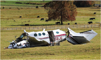
The airplane was located in a large open pasture that sloped downward from west to east. It was aligned on a magnetic heading of 030 degrees. South of the point of impact, power lines crossed the field from west to east. They were about 35 to 40 feet off the ground and 311 feet from the point of impact. The on-scene examination revealed no ground scars, only impact ground gouges, consistent with a right wing-low, nose-low attitude as reported by witnesses. The nose and cockpit area were crushed inward.
There were ground imprints, the same length as the wings. At the end of the left imprint were red lens fragments. At the end of the right imprint were green lens fragments. These ground imprints were immediately forward of both wings, consistent with the airplane rebounding slightly. The right wing was destroyed. The left wing was partially separated at midspan, and the wing tip was separated from the wing. The leading edge was crushed aft to the spar, and the wing was twisted up and aft. The right wing was bent aft and upward along its span, and the leading edge was crushed inward along the lower side. Minimal fuel (approximately one quart) was observed in each nacelle tank. There was no evidence of fuel spillage on the ground, and no fuel stains were observed on the undersides of the wing panels, wing trailing edges, or engine nacelles. There was no smell of fuel at the site.
Both engines and nacelles were partially separated from the wings. Both propeller assemblies remained attached to the engines and were partially buried in the earth. There were no ground scars leading up to the airplane, and there was no evidence of rotation at impact. Control continuity was established from the flight controls to the center of the airplane. Measurements of the elevator and rudder trim were indicative of a neutral position, and aileron trim was in a slight left wing down position. The landing gear and flaps were retracted. Propeller signatures indicate the propellers were not feathered and bore little or no rotational signatures.
Examination of the cockpit revealed power, condition, and fuel shutoff levers were full forward. There was a witness mark on the airspeed indicator at 78 knots. The airplane’s power off stall speed (flaps retracted) was between 78 and 89 knots (minimum weight versus maximum gross weight, respectively).
Tests and Research
The annunciator panel and fuel totalizer were removed from the airplane and sent to NTSB’s Vehicle Recorder (RE-40) and Materials Laboratory (RE-30) Divisions for examination. According to the Vehicle Recorder Specialist’s report, application of electrical power to the fuel totalizer revealed:
l Fuel used: 260 gallons
l Fuel remaining: 123 gallons
According to the Materials Laboratory Specialist’s report, magnification of the annunciator panel light bulbs revealed that the following annunciator lights were illuminated at impact:
l Left generator out
l Left ignition on
l Low fuel pressure (left)
l Fuel crossfeed
l Inverter out
l Low fuel pressure (right)
l Right generator out
l Right ignition on
The fuel management panel located on the left sidewall had been cut away by first responders in order to extricate the pilot. Although intact, the panel had been damaged by impact. Examination of the panel revealed the left and right boost pumps were ON, the left and right fuel transfer switches were OFF, the fuel crossfeed switch was in the AUTO position, and all the fuel system circuit breakers were OPEN. There was a yellow arc on the fuel gauges, denoting minimum fuel that must be in each wing tank before takeoff. The range is from zero to 265 pounds or zero to about 41 gallons in each wing (6.7 pounds per gallon).
An effort was made to trace the airplane’s movements in an attempt to explain the discrepancy between the fuel gauges and the fuel totalizer. On October 9, 2013, the pilot gave instructions to Faith Aviation, the fixed base operator (FBO) at CDH, to put 25 gallons of fuel in each wing tank. When asked if he had a receipt for this transaction, the FBO replied that he did not. The pilot then flew from CDH to PBF, a distance of 65 nm. According to Beech Aircraft, the fuel required for this flight (assuming a cruising altitude of 10,000 feet) would be about 210 pounds, or about 30 gallons. Grider Aviation and Pine Bluff Aviation, both FBOs at PBF, were contacted. It was learned that Tomlinson Avionics had replaced the airplane’s inverter, and the airplane was placed in Tomlinson’s hangar, where it remained until the pilot departed on November 1. Before departure, the pilot purchased a new battery but did not purchase fuel. It was reported that the pilot rarely topped off the airplane with fuel, but would add only enough fuel as necessary to make the trip. The distance between PBF and VBT is about 172 miles.
According to Beech Aircraft, the estimated fuel needed for this flight (assuming a cruising altitude of 17,000 feet) would be about 460 pounds, or 70 gallons.
Conclusion
NTSB investigators either traveled in support of this investigation or conducted a significant amount of investigative work without any travel, and used data obtained from various sources to prepare this aircraft accident report. As the airplane was descending toward its destination airport, the pilot reported to an air traffic controller en route that he needed to change his destination to a closer airport because the airplane was low on fuel. The controller advised him to land at an airport that was four miles away. Shortly after, the pilot contacted the alternate airport’s air traffic control tower (ATCT) and reported that he was low on fuel. The tower controller cleared the airplane to land, and about 30 seconds later the pilot advised that he was not going to make it to the airport. The airplane subsequently impacted a field southeast of the airport. Forty-foot power lines crossed the field 311 feet from the point of impact. It is likely that the pilot was attempting to avoid the power lines during the forced landing and that the airplane then experienced an inadvertent stall and an uncontrolled collision with terrain.
About one quart of fuel was observed in each fuel tank. However, the fuel totalizer showed that 123 gallons of fuel was remaining. Magnification of the annunciator panel light bulbs revealed that the left and right low fuel pressure annunciator lights were illuminated at the time of impact. An examination of the airframe and engines revealed no anomalies that would have precluded normal operation.
About one month before the accident, the pilot had instructed the fixed-base operator at Camden, Arkansas, to put 25 gallons of fuel in each wing tank; however, it is unknown how much fuel was already onboard the airplane. Although the fuel totalizer showed that the airplane had 123 gallons of fuel remaining at the time of the crash, information in the fuel totalizer is based on pilot inputs, and it is likely the pilot did not update the fuel totalizer properly before the accident flight. The pilot was likely relying on the fuel totalizer instead of the fuel gauges for fuel information, and he likely reported his low fuel situation to the ATCT after the annunciator lights illuminated.
The National Transportation Safety Board determines the probable cause(s) of this accident to be: A total loss of power to both engines due to fuel exhaustion. Also causal were the pilot’s reliance on the fuel totalizer rather than the fuel quantity gauges to determine the fuel on board and his improper fuel planning.
About The Author
For more information, in the U.S.A. (N.T.S.B.) The NTSB is an independent Federal agency charged by Congress with investigating every civil aviation accident in the U.S. and significant accidents in other modes of transportation-railroad, highway, marine and pipeline. WEBSITE = http://www.ntsb.gov/ For more information, in CANADA (T.S.B.) The Transportation Safety Board of Canada (TSB) is an independent agency that advances transportation safety by investigating occurrences in the marine, pipeline, rail and air modes of transportation. WEBSITE = http://www.tsb.gc.ca/eng/
View all articles by N.T.S.B..